Aircraft Black Boxes in the Cloud: For Safety, Surveillance, Security or Spying?
Summary
The ubiquitous voice and flight data recorders are critical for determining the causes of an aircraft crash. Typically the initial crash site survey involves the search and recovery of the "Block Boxes". With the advances in technologies, totally new concepts of a real-time online voice/video/flight data recorder were implemented and tested. Such a system is described and evaluated in this webpage. Smart mobile devices are used to capture much of the functionality of a black box and upload data in real time via the Internet to the Cloud; in essence creating an online black box in the Cloud for each aircraft, large or small.
The online or Cloud flight data recorder or "Black Box" will make it possible to prevent mishaps from happening in the first place, and make investigations after a crash much easier. For the same reason, you can apply it and install a Cloud dash cam (driving recorder) for your teenage drivers. But our teens weren’t impressed by that after they were informed. The apps can be downloaded at TrackView.net
Historical Background
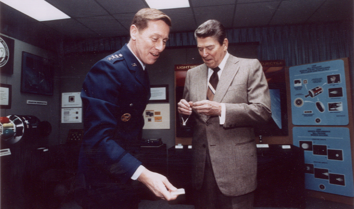
"Space Force" started from Reagan's "Star War", and Cartoonists' rendition of it.

In the 1960’s, U. S. Air Force had a clandestine manned space program to replace CIA U-2 spy planes. U-2 had been shot down multiple times over Russia, Cuba and China. The space program is not officially declassified (PBS NOVA Astrospies).
In the 1980's, President Reagan released the then secret military Global Positioning System (GPS) for civilian use after Korean Airlines Flight 007 was shot down, so that similar tragedies of navigation errors would never happen again. Other countries followed Reagan's open navigation policy, and learned from the advanced navigation/communication technologies. Russian's Glonass, European Union EU's Galileo and China's BeiDou (Northern Dippers) were all made available to civilian use for the cause.
At the same time, former Space spy astronaut General James A. Abrahamson ran the Strategic Defense Initiative (SDI) also known as “Star Wars” during Reagan administration. After retiring from the Air Force, Abrahamson served as an advisor for FAA and other CAA's. He coordinated a project of Air Traffic and Safety Initiative. It was identified that the black box i.e. flight data/voice recorder should be online, not to be tied to an aircraft only. FAA’s Automated Dependent Surveillance – Broadcast (ADS-B) could be augmented to cover the vast (greater than 90%) oceanic aerospace that was the "blind spot" of radars. The General is very low-key, he gave people an impression of a professor rather than a military leader.
Introduction
Let us start by asking the following questions:
How could a modern airliner disappear into thin air? Why we still need to search for the black boxes after aircraft crashes?
What is the difference between safety, security, surveillance and spying?
The answer is: They are all the same in terms of the technologies. It also depends on your point of view. Spying is done without your knowledge. Surveillance is a form of legal action to monitor. Safety and Security can be the outcome of surveillance and spying.
What is the most famous and bizarre notion/quotation in the field/history of espionage?
“Gentlemen do not read each other’s mail”- Yet another Stimson Doctrine, by U. S. Secretary of State Henry Stimson 1929
Looking Forward to the Future: Tracking and Viewing Commercial Aviation (Airline) Flights
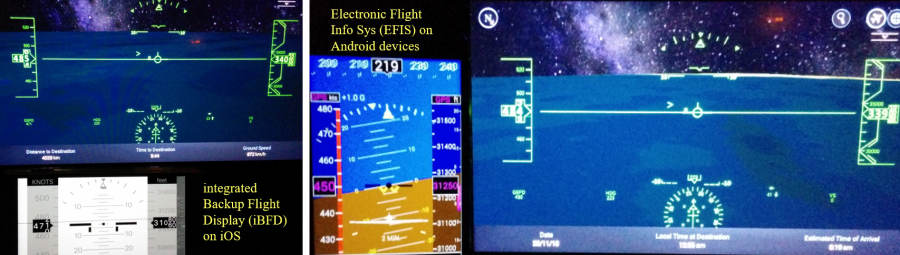
The following tests were conducted aboard general aviation aircraft and airline flights with platform-agnostic apps., that is, they can be run on PC’s, Apple iOS or Android devices. "TrackView", also known as "Find My Phone", has a real-time video monitoring function while Apple’s counterpart "Find My iPhone and FaceTime" are separate apps. TrackView, Find iphone are demonstrations of the vision of an online black box and FAA’s ADS-B. They could have helped to solve the greatest aviation mystery of MH370 had they been known and used at the time. Similar apps will certainly improve air, personal safety and save lives in the future.
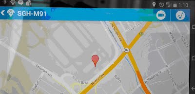
A Southwest Flight 2397 from San
Diego to San Jose, California is illustrated as how the system works. The airborne device was a Samsung Galaxy S4. The ground stations used a PC and a Google Nexus 5 were in the
comfort of a home and SJC airport in San Jose. During the flight tests,
the airborne device reported positions back to the ground stations every five seconds, excluding only very short wifi blackout periods during taking off and landing.
Southwest Airlines uses a KU-band satellite connection for their in-flight wifi. There
are also KA-band satellite connections for airline carriers such as JetBlue, etc. GOGO connections use land-based stations for over-the-land flights. TrackView/Find My Phone is
downloadable from App store, Play store or
trackview.net.
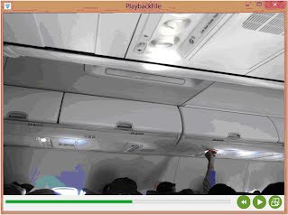

Playback of the video/voice on board while over the ocean, as recorded by a ground station during the flight in real-time. The night vision alone could be of a great help to find out the mystery of Malaysia Airline MH370.
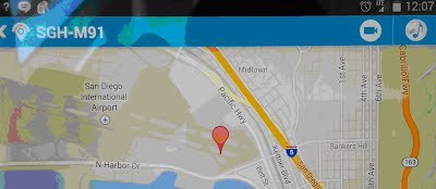
The flight is taxiing from the terminal to the end of runway at the San Diego airport, as seen from our ground stations in San Jose and SJC.
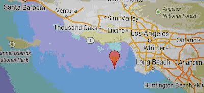

The flight approaches land near Oxnard

The flight approaches San Jose from the South.
The flight arrives at San Jose Airport, taxiing to the terminal.
The following pictures were captured during an oceanic flight ( CI003 from SFO to TPE ):
Readers are encouraged to repeat the tests on your next air travel for entertainment or curiosity. GPS signal reception is a tricky part on board an airliner. Seats next to the windows work fairly well because of the line-of-sight requirement to the GPS satellites. A decent GPS signal repeater will be needed for other seats in a typical passenger cabin. Using a window for the GPS signals would experience an interrupt if the airplane making a turn more than 45 degrees or more because the sky view would be different. A GPS "Cold Start" might take longer than you think. Set your devices correctly, and be patient for the GPS to work. Most windows on a Boeing 787 with an opaque material might block GPS signals. Oceanic flight tests were conducted on flights departing from SFO and OAK airports. The online voice/videos in the passenger cabin were very good. This monitoring function alone could have solve the mystery of what happened inside flight MH370. The locations of the flights were available sporadically. The identified causes were the qualities of GPS repeaters and the WiFi. Those flights were flying high latitude routes. The communication satellites, INMARSAT for example, are geosynchronous and over the equator. The results were not yet as exciting as the Southwest flight.
The industries and FAA should define the specifications for the online black box. If the FAA makes the first move, other national civil aviation authorities, Eurocontrol or CAA's shall follow or vice versa.
Virtual Radar Can Prevent Airliner Shoot Downs, Sheep May Safely Graze!
Malaysian Airlines Flight MH17 was shot down in July 2014, by a Russian-made surface-to-air missile without identifying it. This tragedy could have been avoided by an available technology that was meant to track and identify commercial aircraft. Such equipment and their amateur users are ubiquitous. A specific example is an aviation enthusiast website, FlightRadar24.com, which was the first to publish the loss of Ukraine International Airlines Flight 752 in January 2020, when some Iranian civilian feeders in Tehran uploaded their airspace data to the website.
Such tragic losses of life could have been prevented. The objective of this video is to demonstrate the technology and know-how that should have been used to avoid accidental shoot down of commercial airliners.
We are workers at NASA/Moffett Field in Silicon Valley, and part of the international aviation communities of users of virtual radar technology by means of Automatic Dependent Surveillance-Broadcast (ADS-B). This technology collects local airspace aircraft movement data, then feeds crowd-sourced websites like FlightRadar24.com. We had successfully tested these systems, and also applied the concepts onto other safety/surveillance/spying apps for smart phones, tablet or PC’s. Other similar apps are: Aircraft Spots twitter, OpenADSB, and TrackView.net.
A best-known example of crowd-sourced is Wikipedia, used globally (China excepted). FlightRadar24.com, a Swedish crowd-sourced website, is accumulating ADS-B flight data provided by feeders/contributors from all over the world. This is why the logs of the doomed Ukraine Flight 752 were published first by people, not by any government agency. Such a feat was timely even though the websites have an inherent delay of up to two minutes (latency plus processing time) for the websites to collect, process and filter such large amounts of data.
Only local feeders like us equipped with ADS-B radars can acquire the real-time, originally observed aircraft flight data about the sky immediately above us, as in the earlier cited Iranian civilian feeders in Tehran who provided inputs to FlightRadar24.com. Military air defense forces are using the system as a reference. It is as easy and fun as playing Pokemon Go that children love to do. However, the military of some totalitarian regimes have not as yet; possibly because of no outside information exchange, and having undue concern over foreign conspiracy. To fill this void, the civilian aviation communities, FlightRadar24.com, AirTrafficTower.com are willing to provide virtual radars free of charge to the Iranian Revolutionary Guard, and other potential users in areas of geopolitical tensions such as the South China Sea. This offer is on a strictly non-political, free of governmental oversight basis, solely to prevent accidental shoot down of airliners, thereby saving lives. To apply for the virtual radars, refer to the links presented in this YouTube video description.
Airline accidents, though tragic, have contributed to improving airline safety throughout the decades. There are two noteworthy examples: (1) Korean Airlines KAL007, drifted off course into Soviet airspace, and was shot down in 1983. Two Sukhoi Su-15 fighter jets were ordered to intercept the airliner. The missile was launched without any attempt to contact the airliner by radio. Navigation had been a very tricky art, subject to errors. For centuries, dead reckoning was needed, but it has been said that dead reckoning could lead to death. To prevent such navigation errors from happening again, President Ronald Reagan announced the release of the then secret Global Positioning System (GPS) for civilian use. Glonass, Galileo and Beidou followed. (2) In July 1988 the USS Vincennes, a U.S. Navy guided missile cruiser, shot down Iran Air Flight 655, mistook the Airbus A300 as an Iranian Air Force F-14 fighter jet after trying radio contacts. The incident may have been caused by Flight 655 failing to identify itself. The U.S. government issued notes of regrets and provided compensation to the victims. It was subsequently determined that an automatic airliner identification system would have prevented this incident; ADS-B was the solution.
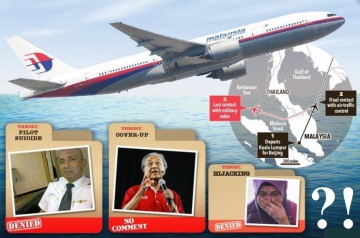
These two and many other accidents prompted the release of advanced U.S. defense technologies such as GPS, the Internet, Cloud computing, digital photography, to support civilian aircraft safety. These technologies are now in everyday use by most people without appreciating the stories behind. The airliner identifying ADS-B had been advocated by the U.S. Federal Aviation Administration (FAA) and International Civil Aviation Organization (ICAO) since the last century. Furthermore, ADS-B has the potential for being an online, real-time or Cloud flight data recorder (black box), ensuring no aircraft will disappear into thin air as did Malaysian Airlines Flight MH370, the most outrageous mystery in aviation history. Nor will there be the expensive recovery of flight data recorders as those of Air France Flight 447 in the Ocean. It is an international effort for all the sovereign nations’ Civil Aviation Authorities (CAA) mandated ADS-B. China is playing a major role of making the equipment.
The ADS-B virtual radars can be stationary or mobile. Because building the system is challenging, the civilian aviation communities, FlightRadar24.com and others have provided instructional videos; the links are provided in the description. Our experience shows, and it is strongly recommended that, the stationary radar be built first, and then converted to mobile if needed. We are showing the instructional video of building mobile radar for studying the signal characteristics which is not available elsewhere. The basic components are similar: a software defined radio (SDR), an antenna, optional band-pass filter, and the computer - a Raspberry PI 3, all of which are made in China, can be purchased online. As stated above, the civilian aviation communities can provide ready-to-use equipment for free to selected parties as mentioned above.
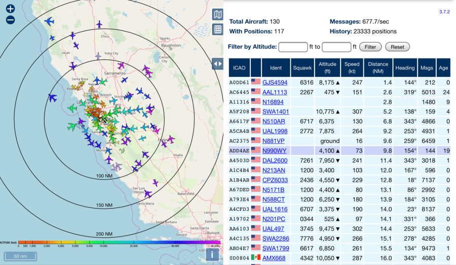
We are located in NASA/Moffett Federal Airfield. Our ADS-B radar is tracking 145 aircraft over the busy San Francisco Bay Area, with a radar range of 200 nautical miles. The antenna is mounted on top of a vehicle, while the receiver, radar computer and power supplies are inside. A smartphone is used as the hot spot Wi-Fi; the virtual radar and a tablet are connected wirelessly while the tablet is used as the radar screen. A Wi-Fi hot spot is required to be in effective range between the radar and display tablet.
We also learned from the aviation enthusiasts in Taiwan about their ADS-B radars watching the sky over Taipei. There were air power muscle shows between the USAF and Communist China’s PLA’s H-6 bombers (replicas of the Soviet Badger) flying around Taiwan during the general election and pandemic 2020. This is Aircraft Spots’ records of B-1B's and B-52's from Guam flying over the Taipei Flight Information Region (FIR) to support Taiwan.
This video is dedicated to the memory of Ernest Mac McCauley, the pilot of the ill-fated B-17 Flying Fortress Nine-O-Nine of the Collings Foundation. He and the crew kindly allowed us to perform flight tests of the TrackView.net, ADS-B and safety surveillance systems, on both the B-17 and B-25 Mitchell bombers.
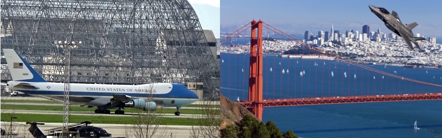
Photos taken at locations in Silicon Valley, around 2019 Fleet Week SF
You can own an Air Traffic Tower to track these flights on your smart devices, mobile or stationary! (Not available in the Flight information websites)
Air Force One approached, landed at Moffett Field, Sept. 2019 The F-35 during Fleet Week SF, Oct. 2019
Skeptical? Here is why, FAA's NextGen safety regulation mandates all aircraft in busy aerospaces must be ADS-B on, including the military (except for combat missions).
A Global Safety System (on Land or in the Air) Tested on

The greatest mystery in aviation history could have been prevented.
Contact us Email: info@AirTrafficTower.com